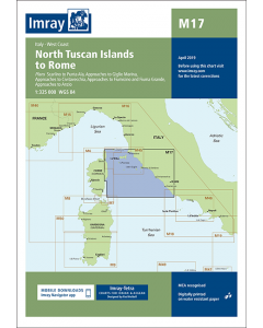
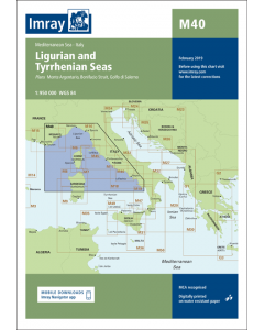
M17 North Tuscan Islands to Rome (Imray Chart)

- FREE Delivery to UK - Spend over £75
- FREE Delivery to Europe - Spend over £150
- Worldwide Delivery Available
Printed and corrected to April 2023
Product Details
Part Number: YOT2080G
Scale: 1:325000
ISBN: 9781846238765
Publisher: Imray Laurie Norie And Wilson Ltd
Manufacturer: Imray Laurie Norie And Wilson Ltd
Edition: 2017
Printed and corrected to: April 2023
Format: Sheet size 640 x 900mm. Waterproof. Folded in plastic wallet.
Language: English
MPN: ICM17-3
Plans included:
- Scarlino to Punta Ala (1:85,000)
- Approaches to Giglio Marina (1:10,000)
- Approaches to Civitavecchia (1:40,000)
- Approaches to Fiumicino and Fiuma Grande (1:50,000)
- Approaches to Anzio (1:50,000)
On this 2017 the latest known depths have been applied. Harbour developments at Civitavecchia and Fiumicino are included as is the restricted area on the approach to Anzio. The Corsican Channel TSS is shown, as are the extents of Marine Protected Areas on this chart. The chart specification has been improved to show coloured light flashes. There has been general updating throughout.