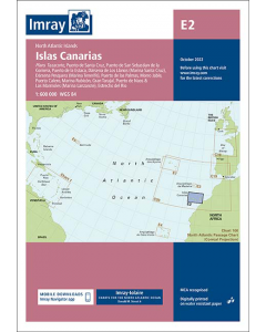
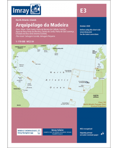
E2 Islas Canarias (Imray Chart)

- FREE Delivery to UK - Spend over £75
- FREE Delivery to Europe - Spend over £150
- Worldwide Delivery Available
North Atlantic Islands Imray-Iolaire Chart
Printed and corrected to October 2022
Product Details
Part Number: YOT0996
Scale: 1:600000
ISBN: 9781786794284
Publisher: Imray Laurie Norie And Wilson Ltd
Manufacturer: Imray Laurie Norie And Wilson Ltd
Edition: 2022
Printed and corrected to: October 2022
Format: Sheet size 640 x 900mm. Waterproof. Folded in plastic wallet.
Language: English
MPN: ICE2-4
Plans included:
Tazacorte (1:10 000)
Puerto de Santa Cruz (1:12 500)
Puerto de la Estaca (1:7500)
Puerto de San Sebastian de la Gomera (1:10 000)
Dársena de Los Llanos (Marina Santa Cruz) (1:17 500)
Dársena Pesquera (Marina Tenerife) (1:17 500)
Puerto de las Palmas (1:30 000)
Morro Jable (1:12 500)
Gran Trajal (1:10 000)
Marina Rubicón (1:25 000)
Puerto Calero (1:15 000)
Puerto de Naos & Los Marmoles (Marina Lanzarote) (1:12 500)
Estrecho del Río (1:50 000)
Imray-Iolaire charts for Atlantic Islands are widely acknowledged as the best available for the cruising sailor. They combine the latest official survey data with first-hand information gathered over 60 years of research by Don Street Jr and his wide network of contributors. Like all Imray charts, they are printed on water resistant Pretex paper for durability, and they include many anchorages, facilities and inlets not included on official charts.
This edition includes the latest official data combined with additional information sourced from Imray's network to make it ideal for small craft. It includes the latest official bathymetric surveys. The finished harbour works at Puerto de Naos & Los Marmoles and Playa Blanca (Lanzarote) are included. There has been general updating throughout.