2120 North Sea - Nieuwpoort to Den Helder Chart Atlas

- FREE Delivery to UK - Spend over £75
- FREE Delivery to Europe - Spend over £150
- Worldwide Delivery Available
Imray folio for Nieuwpoort to Den Helder (including North Sea Passage Planning sheet). Includes free mobile download: Imray digital charts for use on the Imray Navigator app (Apple and Android)
Product Details
Part Number: YOT0862
Scale: 1:1(Various)
ISBN: 9781786795168
Publisher: Imray Laurie Norie And Wilson Ltd
Edition: 2025
Printed and corrected to: March 2025
Format: Folio - A2 Size - Wirobound
Language: English
MPN: IC2120-7
Part of Imray’s popular small format chart coverage for the Netherlands, this atlas is a convenient A2 format, wirobound along one edge.
It includes a voucher code to download ID10 Imray North Sea charts into Imray Navigator (our app for iPad, iPhone and Android).
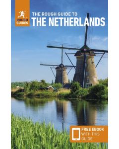
It covers the North Sea coast from the Belgian-French border, through the Zeeland, South Holland and North Holland coasts up to and including Den Helder.
It includes all of the navigational charts and tidal data required for coastal passage and approach. Also included is a larger-format passage planning sheet for plotting routes across the North Sea.
1. North Sea Coast – Nieuwpoort to Hoek Van Holland (1:300 000)
2. North Sea Coast – Hoek van Holland to Texel (1:300 000)
3. Approaches to Nieuwpoort and Oostende (1:100 000) includes plans Niewpoort (1:30 000) and Oostende (1:20 000)
4. Oostende to Westkapelle (1:100 000) includes plans Blankenberge (1:15 000) and Zeebrugge (1:35 000)
5. Entrance to the Westerschelde (1:50 000) includes plans Breskens (1:15 000), Vlissingen (1:20 000) and Cadzand-Bad (1:10 000)
6. Westkapelle to Westhoofd (1:100 000) includes plan Roompotsluis (1:30 000)
7. West Schouwen to Hoek van Holland (1:100 000) includes plan Stellendam (1:30 000)
8. Hoek van Holland to IJmuiden (1:125 000) includes plans Scheveningen (1:15 000) and IJmuiden (1:35 000)
9. IJmuiden to Den Helder (1:125 000)
10. Approaches to Den Helder (1:50 000) includes plan Den Helder (1:20 000)
11. Southern North Sea passage planning chart (1:500 000)
This edition includes the latest depth surveys and windfarm details along with adjusted routes across the North Sea. There has been general updating throughout.
Commended for the John C Bartholemew Award for Thematic Mapping at the 2016 British Cartographic Society Awards.