Firth of Clyde Pack

- FREE Delivery to UK - Spend over £75
- FREE Delivery to Europe - Spend over £150
- Worldwide Delivery Available
CCC Sailing Directions & Imray Chart Pack for Firth of Clyde.
Product Details
Part Number: PIL0340;YOT0852
Edition: 2020
Printed and corrected to: No
Publisher: Imray Laurie Norie And Wilson Ltd
Language: English
Format: No
Firth of Clyde
Part of the Clyde Cruising Club’s Sailing Directions and Anchorages series, Firth of Clyde extends beyond its titled area to the coast of Northern Ireland (Rathlin Island to Belfast Lough) and on the Scottish side southwards from Stranraer to Portpatrick and beyond to the Solway Firth and Cumbria.
Firth of Clyde covers everything from the busy waters of the Firth of Clyde and River Clyde to the more remote areas of the wider estuary and connected lochs, including the protected and beautiful Kyles of Bute and Loch Riddon, Loch Fyne and the Crinan Canal. Coverage then extends west and south to encompass North Channel and Solway Firth.
This new edition, updated by Geoff Crowley, continues the long-respected legacy of CCC publications for cruising sailors. The North Channel section has been extended to include details for Belfast itself. New photographs throughout illustrate the text and help orientate the navigator. Details on plans have been updated with reference to the new Imray 2900 Firth of Clyde chart pack for the area. References to Bob Bradfield’s useful Antares large scale charts are also included.
Whether you are a local sailor or a first-time cruising visitor, Firth of Clyde is an essential companion in these waters.
Updates and corrections are available via the Clyde Cruising Club website as below.
Includes free mobile download: Imray Digital Charts for West Britain and Ireland.
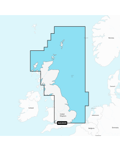
2900 Firth of Clyde Chart Pack
This complete redesign of the 2900 Firth of Clyde chart pack now include more detailed coverage of the area and comes as a paper and digital edition.
Created in association with the Clyde Cruising Club for use alongside their sailing directions, coverage includes detail of this delightful area of Scotland with passages to Northern Ireland and references to the popular large scale Antares Charts.
The 16 sheets in this pack provide all the necessary information for passage planning, detailed approach to yacht havens and marinas, and the numerous anchorages and sailing areas recommended for small craft.
Coverage includes the Firth of Clyde, lochs to the north of the Upper Clyde, the Kyles of Bute and Loch Fyne, and Kilbrannan Sound to the Mull of Kintyre. This expanded edition also includes coverage of the North Channel, detailing passage from the Firth of Clyde and Loch Ryan to Belfast Lough.
Charts included:
- Firth of Clyde (1:210 000)
- The North Channel (1:210 000)
- Aisla Craig to Ayr (1:75 000) includes plans Girvan (1:6000), Ayr (1:10 000)
- Ayr to Ardrossan (1:75 000) includes plans Troon (1:12 500), Irvine (1:17 500), Ardrossan (1:10 000)
- Pladda to Lamlash Harbour (1:30 000)
- South of Bute & the Cumbraes (1:30 000) includes plans MiIlport (1:15 000), Largs Yacht Haven (1:15 000)
- Upper Clyde (1:50 000) includes plans Kip Marina (1:15 000), Rothesay Bay (1:10 000), Rothesay Harbour (1:5000)
- Long Loch & Gareloch (1:50 000) includes plans Continuation of Long Loch (1:50 000), Continuation of River Clyde (1:100 000), Dumbarton (1:15 000), Bowling (1:15 000), Approaches to Rhu (1:15 000), Holy Loch Marina (1:12 500)
- Kyles of Bute (1:30 000) includes plans Continuation of Loch Striven (1:30 000), Continuation of Loch Riddon (1:30 000), Port Bannatyne Marina (1:10 000), Burnt Islands (1:10 000), Caladh Harbour (1:10 000)
- Inchmarnock Water (1:30 000)
- Lower Loch Fyne (1:50 000) includes plans Portavadie (1:25 000), East Loch Tarbert (1:8000), Ardrishaig (1:10 000)
- Upper Loch Fyne (1:50 000) includes plans Continuation of Loch Fyne (1:50 000), Loch Gair (1:25 000), Minard Narrows (1:25 000), Invaray (1:25 000)
- Inchmarnock to Kilbrannan Sound (1:50 000) includes plan Loch Ranza (1:22 500)
- Carradale to Sanda Island (1:75 000) includes plans Campbeltown Loch (1:35 000), Campbeltown Harbour (1:7500), Sanda Island (1:30 000)
- Aisla Craig to Loch Ryan (1:75 000) includes plan Stranraer (1:12 500)
- Belfast Lough to Carnlough (1:90 000) includes plans Carrickfergus (1:15 000), Bangor Bay (1:17 500)