Isles of Scilly Pack

- FREE Delivery to UK - Spend over £75
- FREE Delivery to Europe - Spend over £150
- Worldwide Delivery Available
Pack includes Imray Pilot Book the Isles of Scilly and the 2400 West Country Atlas.
Product Details
Part Number: PIL0205;YOT0854
Edition: No
Printed and corrected to: No
Publisher: Imray Laurie Norie And Wilson Ltd
Language: English
Format: No
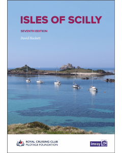
Isles of Scilly
This new edition of this comprehensive guide to the Isles of Scilly has been completely revised and updated. The background information on the islands, their history and flora and fauna has been expanded and this new edition also sees the introduction of useful waypoints.
The Royal Cruising Club Pilotage Foundation’s guide is a must for anyone planning an extended visit to this beautiful archipelago on the edge of the Atlantic.
Includes free mobile download: Imray digital charts for the English Channel.
2400 West Country Atlas
A convenient A2 format chart pack of The West Country provided in a sturdy plastic wallet.
This fully revised edition of our popular 2400 West Country chart pack includes the latest official UKHO data, combined with additional information sourced from Imray's network to make it ideal for small craft.
The chart pack includes all the navigational charts and tidal data for passage, approach and mooring.
2400.1 Land’s End to Trevose Head
1: 180 000 WGS 84
Includes plans Newquay Bay (1:10 000) and Saint Ives (1:15 000)
2400.2 Approaches to the Isles of Scilly
1: 120 000 WGS 84
2400.3 Isles of Scilly
1: 40 000 WGS 84
Includes plan St Mary’s Road (1:25 000)
2400.4 River Camel
1: 30 000 WGS 84
Includes plan Padstow Harbour (1:10 000)
2400.5 Salcombe Harbour
1: 15 000 WGS 84
Includes plan Salcombe (1:9000)
2400.6 River Yealm
1: 12 500 WGS 84
Includes plan Continuation of River Yealm (1:15 000)
2400.7 River Fowey
1: 9000 WGS 84
Includes plan Continuation to Lostwithiel (1:20 000)
2400.8 Dartmouth to Fowey
1: 150 000 WGS 84
Includes plans Polperro (1:3500) and Looe (1:10 000)
2400.9 Fowey to Lizard Point
1: 110 000 WGS 84
Includes plans Mevagissey Harbour (1:3500) and Gorran Haven (1:30 000)
2400.10 Lizard Point to Land’s End
1: 75 000 WGS 84
Includes plans Penzance (1:12 000), Newlyn Harbour (1:10 000) and Mousehole (1:5000)
2400.11 Helford River
1: 17 000 WGS 84
Includes plan Continuation of Helford River to Gweek (1:17 000)
2400.12 Falmouth Harbour
1: 20 000 WGS 84
Includes plans Mylor Yacht Harbour (1:10 000), Falmouth Marina (1:5000) and Falmouth Inner Harbour (1:10 000)
2400.13 Plymouth Harbour
1: 20 000 WGS 84
Includes plans King Point & Millbay Marinas (1:10 000) and Continuation of River Yealm (1:20 000)
2400.14 Plymouth to Saltash and Saint Germans
1: 20 000 WGS 84
Includes plans Mayflower Marina (1:5000), Sutton Harbour and Queen Anne’s Battery Marina (1:7500) and Plymouth Yacht Haven (1:5000)
2400.15 Saint Mary’s, Tresco and Surrounding Islands
1: 20 000 WGS 84
2400.16 River Dart
1: 15 000 WGS 84
Plans Kingswear, Continuation to Totnes
Various individual sheets of this chart pack are available separately. These form part of our ‘small format Y chart series’ that mirror coverage of charts from the corresponding atlas and printed A2 size. For details of these please see their individual web page (Y43, Y44, Y45, Y46, Y47, Y48, Y49 and Y50).
A voucher code to download ID20 Imray English Channel charts into Imray Navigator (Imray app for iPad, iPhone and Android) is included with this chart pack.