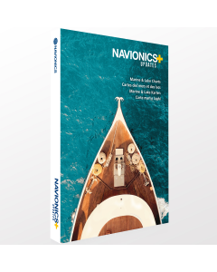
Navionics+ Large - North Europe & Mediterranean

- FREE Delivery to UK - Spend over £75
- FREE Delivery to Europe - Spend over £150
- Worldwide Delivery Available
Electronic Nautical Charts on (m)SD card for compatible chart plotters
Product Details
Part Number: NAV5213
Manufacturer: Navionics
Scale: No
Publisher: Navionics
Format: microSD/SD Card
Technology: Navionics+
Size: Large
How to Order your Navionics+ Charts in 4 Easy Steps
Step 1 - Browse and choose your chart coverage area from the image (click on it to enlarge)
Step 2 - Select your chosen Chart Area from the drop down list
Step 3 - Add your Navionics+ compatible chart plotter make and model number into the text box
You are now ready to Add to Basket.
CHART COVERAGE
Navionics+ Chart coverage areas for North Europe & Mediterranean:
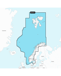
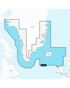
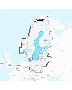
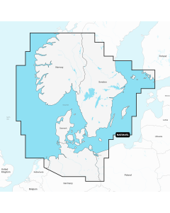
- 20XG - Greenland & Iceland
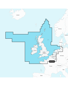
- 28XG - UK, Ireland & Holland
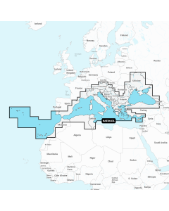
- 43XG - Mediterranean & Black Sea
- 44XG - Baltic Sea
- 45XG - Skagerrak & Kattegat
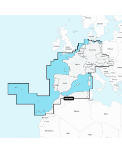
- 46XG - Central & West Europe
- 49XG - Norway
- 52XG - Russia West
FEATURES
Nautical Chart
Nautical Chart is the all essential cartographic reference for boaters worldwide. If you’re looking for an accurate and thorough map of lakes and marine areas, Nautical Chart is the resource you’ll want by your side.
Use the map to study port plans and safety depth contours, identify tides & currents, and locate navigation aids, nearby marine services and more!
Enriched Over 30 Years
Continuously expanded with data from numerous highly qualified public and private sources, including our own surveys, Notices to Mariners and data reported by users.
Award-Winning
Nautical Chart has been honored with recognition and awards around the world. It's internationally renowned as a top-notch reference, both for private boaters and by companies that employ our charts in their everyday business.
Daily Updates
We make around 2,000 updates to Nautical Chart every day! A one year subscription to Daily Updates and advanced features is included when you purchase any new product.
SonarChart™
High Def 1 ft/0.5 m detail
SonarChart is an HD bathymetry map featuring extraordinary bottom contour detail for marine and lakes, great for increasing awareness of shallow waters and for locating fishing areas at any depth level.
Want better charts? Go boating!
SonarChart is constantly enhanced by millions of sonar logs contributed from boaters like you. Navionics accepts sonar logs recorded with the vast majority of sonar/plotter brands and mobile devices. These are integrated with existing data, updating SonarChart to reflect the ever-changing conditions of sea, lake and river bottoms.
Daily Updates
We integrate sonar log contributions using advanced integration processes, to update SonarChart every day along with Nautical Chart and Community Edits. A one year subscription to Daily Updates and advanced features is included when you purchase any new product.
Community Edits
Local inputs, great benefit
With the help of millions of the Boating app users who are continuously on the water, all kinds of valuable local information such as seasonal buoys, lights, rocks, moorings, boat ramps, and points of interest like restaurants and provisioning shops are constantly revised and enhanced.
Millions of Boaters
Additions to Nautical Chart are shared by millions of app users from every part of the world. Think of the value of receiving recommendations about places you don't know from people who have experienced them directly before you!
Leave Your Mark!
Become an author by adding any information you believe might be of interest to you and other boaters simply by registering from the app and then selecting the icon that represents the object you want to insert (or, you can ask Navionics to modify the official data).
Self-Monitored
Any user can comment, rate, modify or delete Community Edits. All edits are signed by registered users. Community Edits are a separate layer from official data and can be switched on and off.
Daily Updates
You may be aware of changes in sea or lake data just because you are on the spot, so let us know of them! Community Edits are updated daily along with Nautical Chart and SonarChart. A one year subscription to Daily Updates and advanced features is included when you purchase any new product.
Daily Updates
Dock-to-dock Autorouting
SonarChart™ Live
Advanced Map Options
Plotter Sync
Navionics+ Updates

Navionics+ Large - North Europe & Mediterranean
-
Navionics+ Large - UK, Ireland and Holland
Special Price £220.00 Regular Price £229.99Stock In stock -
Navionics+ Large - Europe, Central & West
Special Price £220.00 Regular Price £229.99Stock In stock -
Navionics+ Large - Mediterranean and Black Sea
Special Price £220.00 Regular Price £229.99Stock In stock -
-
-
-
Navionics+ Large - Scandinavia, South & Germany, North
Special Price £220.00 Regular Price £229.99Stock In stock