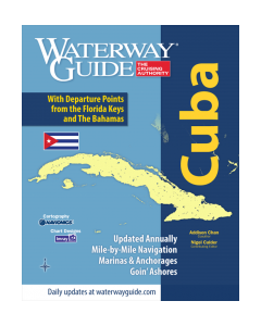
Reg. 10.4: NV.Atlas Cuba - Southeast (Trinidad to Cabo Maisi)

- FREE Delivery to UK - Spend over £75
- FREE Delivery to Europe - Spend over £150
- Worldwide Delivery Available
UNAVAILABLE
This atlas contains a download code for all charts in this area to be used with the nv chart app. The app is compatible with Apple: iOS/MacOSX, Android & Windows: 7/8/10.
Product Details
Part Number: YOT3572
Scale: 1:1(Various)
ISBN: 9783932414442
Publisher: NV Charts
Edition: 2016
Printed and corrected to: No
Format: Combipack - Paper / Download and app
MPN: 9783932414442
Edition: 2015/16
Format: Combipack paper / digital and app
nv-charts Reg. 10.4, Cuba Southeast, Cienfuegos to Cabo Maisi
- Includes Harbour & Anchorage Charts
- 8 Passage Charts - 36 Coastal Charts + Details
- GPS Charted Waypoints
Size: [Closed] H (16.5") x W (11,7")
The nv-charts are characterised by fine contours and easy to distinguish colour graduations of the depth lines – turquoise for coral reefs, red for the 2-meter-line and blue for the 5-m-areas. Presented in a handy, user friendly size, a thick plastic envelope protects the charts, enabling them to be easily stored.
The importance of good graphical representation of the topography when sailing in the Caribbean is essential. Well marked rivers, towns and street plans all help to give a clear overall view of the shoreside facilities of the islands.
Red numbered waypoints with coordinates based on WGS 84 enable yachtsmen to navigate using their GPS instruments. Heights and depths are given in the internationally accepted format of meters. Large scale approaches and land contour markings simplify the entrance into anchorages.
Reg. 10.4 Cuba Southeast
Passage Charts
C0 Caribbean Sea 1: 6,500,000
C1 Cienfuegos to Cabo Cruz 1: 900,000
C2 Cuba Southeast 1: 900,000
C3 Cienfuegos to Cayo Bretón 1: 340,000
C4 Cayo Bretón to Cabeza del Este 1: 340,000
C5 Cabeza del Este to Cabo Cruz 1: 340,000
C6 Cabo Cruz to Santiago de Cuba 1: 340,000
C7 Santiago de Cuba to Cabo Maisí 1: 340,000
Coastal Charts
C8 Ancón to Canal de Tunas 1: 140,000
C9 Cayo Bretón to Golfo de Ana María 1: 140,000
C10 Golfo de Ana María North 1: 140,000
C11 Golfo de Ana María South 1: 140,000
C12 Golfo de Ana María to Cabeza del Este 1: 140,000
C13 Cabeza del Este to Banco de Buena Esperanza 1: 140,000
C14 Banco de Buena Esperanza to Pta. Guá 1: 140,000
C15 Pta. Guá to Cabo Cruz 1: 140,000
Approaches & Details
C16 Ancón to Cayo Blanco de Casilda 1: 60,000
C17 Canal de Tunas to Cayo Blanco de Zaza 1: 60,000
C18 Cayo Bretón 1: 60,000
C19 Cayos de Ana María 1: 60,000
C20 Cayos Cuervo to Algodón Grande 1: 60,000
C21 Canal del Pingüe 1: 60,000
C22 Cayos de Manzanillo 1: 60,000
C22A Canal Cuatro Reales 1: 60,000
C23 Canal de Madrona 1: 60,000
C24 Cabo Cruz 1: 60,000
C25 Bahía de Cienfuegos 1: 40,000
C26A Cienfuegos Approach 1: 20,000
C26B Cienfuegos 1: 20,000
C26C Santa Cruz del Sur 1: 20,000
C27 Bahía de Casilda 1: 20,000
C27A Pasa Boca de Juan Grin 1: 25,000
C27B Estero Boca Grande 1: 20,000
C27C Estero Vertientes 1: 20,000
C28A Cayo Blanco de Casilda 1: 30,000
C28B Bahía de Pilón 1: 30,000
C28C Chivirico 1: 20,000
C29 Bahía de Santiago de Cuba 1: 25,000
C29A Ensenada Marea del Portillo 1: 20,000
C29B Approach Santiago de Cuba 1: 15,000
C30 Bahía de Guanatánamo 1: 60,000
C30A Puerto de Baitiquiri 1: 12,000
C30B Puerto Escondido 1: 20,000
C30C Passage Bahía de Guanatánamo 1: 30,000