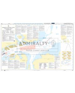
ADMIRALTY Chart 5527: Mariners' Routeing Guide Singapore Strait, Eastern Part

- FREE Delivery to UK - Spend over £75
- FREE Delivery to Europe - Spend over £150
- Worldwide Delivery Available
Mariners' Routeing Guide, Singapore Strait, Eastern Part.
Product Details
Part Number: 5527
Scale: No
Publisher: UK Hydrographic Office
Edition: Feb-23
Printed and corrected to: date of order
Format: Printed on demand (not returnable), at least approximately 107 x 71.5cm, folded at least once. Please contact us if you would like your chart unfolded.
MPN: BA5525
Mariners' Routeing Guide, Singapore Strait, Eastern Part.
1° 00´·00 N. — 1° 33´·72 N., 103° 49´·80 E. — 104° 42´·66E.
A new chart to provide improved coverage for passage planning in the Singapore Strait. Two Mariners' Routeing Guides, Charts 5524 and 5527, now cover the Singapore Strait with Chart 5525 covering the Malacca Strait.
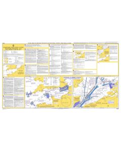
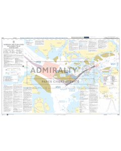
ABOUT MARINER'S ROUTEING GUIDES
Essential routeing information to help bridge crews safely navigate through some of the world’s busiest and most complex shipping routes.
Each Mariners' Routeing Guide includes:
- Verified information highlighting dangers or warnings to navigation, limited depths and dense traffic areas. This additional information, when used alongside official navigational charts, can help to increase situational awareness and reduce the risk of damage caused by collisions and groundings.
- Clear guidance on traffic separation schemes and routeing measures that have been adopted by the IMO and national authorities.
-
Weekly updates and new editions to help maintain high levels of accuracy and safety. Some routeing guides also include ADMIRALTY QR codes for quick access to a list of all Notices to Mariners (NMs) that affect each chart.