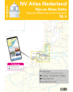
2140 Rijn and Maas Delta

- FREE Delivery to UK - Spend over £75
- FREE Delivery to Europe - Spend over £150
- Worldwide Delivery Available
Imray folio for Rijn and Maas Delta. Includes free mobile download: Imray digital charts for use on the Imray Navigator app (Apple and Android)
Product Details
Part Number: YOT0865
Scale: 1:1(Various)
ISBN: 9781786790842
Publisher: Imray Laurie Norie And Wilson Ltd
Edition: 2019
Printed and corrected to: edition date
Format: Folio - A2 Size - Wirobound
MPN: IC2140-2
Part of Imray’s popular small format chart coverage for the Netherlands, this atlas is a convenient A2 format, wirobound along one edge.
Includes download code for more than 140 digital charts covering all of the Netherlands on the Imray Navigator charts app.
Includes extensive coverage of Nieuwe Waterweg, Nieuwe- and Oude Maas, Brielse Meer, Spui, Noord, Dortsche Kil, Hollandsch Diep, Haringvliet, Volkerak and Grevelingenmeer. Also included are approach charts to the Maas and Haringvliet entrances, and detail of the standing mast routes between Rotterdam and Amsterdam.
- Rijn and Maas Delta Overview Chart (1:250 000)
- Approaches to The Maas (1:45 000)
- Approaches to Haringvliet (1:45 000)
- Europoort & entrance to Nieuwe Waterweg (1:25 000)
- Nieuwe Waterweg - Hoek van Holland to Maassluis (1:25 000) includes plans Hoek van Holland (1:10 000) and Maassluis (1:15 000)
- Brielse Meer (1:15 000) includes plan Brielse Meer - continuation to Zwartewaal (1:15 000
- Maassluis to Nieuwe Maas & Oude Maas (1:20 000)
- Rotterdam (1:20 000)
- Rotterdam to Alblasserdam (1:20 000)
- Approaches to Dordrecht (1:20 000)
- Oude Maas - Hoogvliet to Puttershoek (1:20 000) includes plan Puttershoek (1:10 000
- Spui (1:20 000) includes plans Zuidland & Goudswaard (1:10 000) and Nieuw Beijerland (1:10 000)
- Dortsche Kil to Hollandsch Diep (1:25 000) includes plans Strijensas (1:10 000), Moerdijk (1:10 000) and Noordschans (1:10 000)
- Haringvliet West (1:30 000) includes plans Hellevoetsluis (1:15 000) and Middelharnis Entrance (1:10 000)
- Haringvliet East (1:30 000) includes plans Stad aan’t Haringvliet (1:10 000), Den Bommel (1:10 000) and Hitsertse Kade (1:10 000)
- Hollandsch Diep East & Volkerak (1:30 000) includes plans Willemstad (1:12 500), Dintelsas (1:20 000) and Benedensas (1:15 000)
- Grevelingenmeer East to Krammersluizen (1:30 000) includes plans Herkingen (1:10 000) and Bruinisse (1:15 000)
- Grevelingenmeer West (1:30 000) includes plans Scharendijke (1:20 000), Den Osse ( 1:20 000), Brouwershaven (1:10 000) and Ouddorp (1:10 000)
- Standing Mast Routes - Rotterdam to Amsterdam (South sheet) (1:50 000)
- Standing Mast Routes - Rotterdam to Amsterdam (North sheet) (1:50 000) includes plan Amsterdam - Houthaven to Sixhaven (1:22 500)