HP33 Waterstanden en Stromen 2019

- FREE Delivery to UK - Spend over £75
- FREE Delivery to Europe - Spend over £150
- Worldwide Delivery Available
UNAVAILABLE
Dutch Tidal Publication
Product Details
Part Number: NLPUB33-19
Edition: 2019
Printed and corrected to: No
Publisher: Dutch Hydrographic Office
Format: Paperback
Annually under the title HP33 shows the combined release of water (including the hour teeth 17 stations) and tidal currents along the Dutch coast and adjacent area.
HP33 gives a large number of sites per hour, the rise of water above the reducatievlak (of the chart). There are also tidal curves in the water at spring tides and neap tide. You can calculate the water level for each time using the tidal curves in the HP 33.
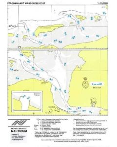
Current Atlas
However, the HP33 is greater; a large number of trades and port calls include HP33 flow charts. On these maps, you can see how for each hour the flow direction and strength is on a large number of positions. With these flow charts you always have a clear picture of the progress of the tidal flows in a particular area. Included are flow charts for Southern North Sea, Western and Eastern Scheldt, Wadden West Wadden East, Lower River and starting, Hook of Holland, Scheveningen, IJmuiden, Texel and Den Helder.
Being able to calculate the rise and by means of interpolation with the aid of a tidal curve is a part of the conditions of examination of the examination Theoretical Coastal Navigation. If you learn this exam it is advisable to purchase an HP 33 and lots of exercise. You may someone can take a used one. On board you will always have the latest edition of course!
The CD-ROM Exam Coastal Navigation are many practice questions for calculating the rise and water levels. All data to answer these questions are the questions included on the CD. Also on the exam will give you all the information and the exam so you do not have to bring a book.
![1820 IJsselmeer, Markermeer, Noordzeekanaal en Ijsseldelta [PRE-ORDER]](https://www.bookharbour.com/media/catalog/product/cache/f073062f50e48eb0f0998593e568d857/n/l/nl1820.jpeg)