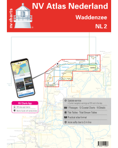
NL2: NV Atlas Nederland - Waddenzee

- FREE Delivery to UK - Spend over £75
- FREE Delivery to Europe - Spend over £150
- Worldwide Delivery Available
This atlas contains a download code for all charts in this area to be used with the nv chart app. The app is compatible with Apple: iOS/MacOSX, Android & Windows: 7/8/10.
Product Details
Part Number: YOT0006NL2
Scale: 1:1(Various)
ISBN: 9783932414466
Publisher: NV Charts
Edition: 2024
Printed and corrected to: edition date
Format: Combipack - Paper / Download and app
Language: Dutch, German
MPN: 9862
The NL2 is the ideal map to experience the Waddenzee region. The water sports area is characterised by a high tidal range and a rugged partly almost untouched landscape. The map covers the German island of Borkum but then quickly moves over to the Dutch side. There you will find among others Schiermonnikoog Ameland Terschelling Vlieland and Texel the five inhabited islands in the Wadden Sea all of which also have a large marina. But the coastal areas from the mouth of the Ems over Lauwersoog to the beginning of the Ijsselmeer are also covered. The current Waddenzee nautical chart contains all nautically relevant information such as depth buoyage restricted areas tides etc. and is the basis for a safe voyage.
In this sea area you can expect rough winds exceptionally changeable tides and sometimes longer waiting times when entering and leaving a port. It is also helpful to have familiarised yourself with the conditions in the Wadden Sea before setting off. But in return you will be rewarded with a nature that sometimes seems to have been abandoned by man. Long bright beaches dunes small fishing villages and beautiful sandbanks are the order of the day here. An area that may demand a little flexibility but in which you can also let yourself drift very well! Thanks to the clear layout of the nautical chart the sports skipper can quickly find approaches harbours and anchorages and is pointed to navigationally important details that also appear in the nv charts app. The tide data and current information are also available for the navigation programme and app. The chart series impresses with its detailed scales and optimal sheet cuts.
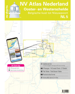
This chart set contains
- 1 oversailer
- 11 precinct charts
- 17 detailed charts
- Code for the nv charts App
- Digital charts & navigation program 365 days licence
- Current data in the digital charts
- Tidal calendar
- Paper harbour plans & Digital
- Meets legal requirements for up-to-date paper charts on board
Update - Update
The chart sets for the Netherlands are published annually in updated editions. For the digital nautical charts updates are made available as downloads at the beginning of the season. Up-to-date nautical charts are the basis of safe navigation. NV Charts offers a monthly updating service for its North Sea charts from April to October. So that your charts are always up to date.
NV Atlas chart format
NV Charts nautical charts are available in an outstandingly practical, handy atlas booklet format and thus offer many advantages over formats from other manufacturers. The nautical chart series have been designed by nautical experts and passionate water sports enthusiasts with the needs of recreational boating in mind.
The NV Atlas has a very flat staple binding in the middle, so that the course triangle can also be used there without any problems. This innovative development makes it possible to look up charts quickly and always have them in the best possible order at the same scale. The NV Atlas is delivered in a plastic cover protected against splash water. This modern nautical chart format is very popular on sailing boats as well as on motor yachts and is the preferred choice of many of our customers.
NV Charts navigation app
All NV Charts nautical charts also include an access code to the digital nautical charts in the NV Charts app and can thus be easily downloaded and used for offline navigation with the NV Charts app on iOS, Android, PC and Mac or also in the web browser.
The NV Charts app is the ideal addition on mobile devices. With the app, you can already plan a detailed route at home and thus prepare for your journey in the best possible way in conjunction with the paper chart. The app is intuitive to use and, thanks to an identical map image, you can orientate yourself on paper and digitally in a matter of seconds. The most up-to-date information is essential to navigate safely on the water with your sailboat or motorboat.
With the NV Charts app, you now have the opportunity to become part of the chart community. You can mark harbours, anchorages and navigation warnings on the digital nautical chart and also add interesting places beyond navigation, such as restaurants, with pictures and comments and share your experiences with other users. In addition, the NV Charts app offers an automatic routing function, search and all navigation functions for GPS navigation with your phone or tablet. More information at: nvcharts.com/app
More PC navigation apps: NV Verlag / NV Charts nautical charts can also be used in many other nv.digital compatible PC navigation programs such as NV Chart Navigator or Open CPN.
Our recommendation
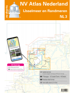
In the south of NL2 is a seamless transition to NL3 which covers the popular sailing area around the Ijsselmeer. If you need a detailed oversailer to get from the German North Sea to the waters of the UK or France the NL1 is the perfect map for you!
Including maps and scales
Oversailer
C1 Borkum - Den Helder 1:375.000
District maps
C2 Texel - Schulpengat 1:50.000 C3 Den Helder - Den Oever 1:50.000 C4 Texelstroom - Eierlandsche Gat 1:50.000
C5 Harlingen - Texelstroom - Makkum 1:50.000 C6 Vlieland - Vliestroom 1:50.000 C7 West-Terschelling - Harlingen 1:50.000 C8 Ameland - Borndiep 1:50.000 C9 Ameland 1:50.000 C10 Schiermonnikoog - Lauwersoog 1:50.000 C11 Schiermonnikoog - Westereems 1:50.000 C12 Borkum - Eemshaven 1: 50.000
Details
C13A Kornwerderzand - Makkum 1:20.000 C13B Borkum Haven 1:15.000 C13C Den Helder 1:15.000 C14A Den Oever 1:20.000 C14B Pollendam - Harlingen 1:20.000 C14C Nes 1:10.000 C14D Harlingen 1:15.000 C15A Oost Vlieland 1:10.000 C15B Aanloop Oost-Vlieland C15C Oudeschild 1:10.000 C15D West-Terschelling 1:10.000 C15E Aanloop West-Terschelling 1:30.000 C16A Lauwersmeer 1:30.000 C16B Zoukamp 1:15.000 C16C Aanloop Schiermonnikoog 1:30.000 C16D Schiemonnikoog 1:5.000 C16E Lauwersoog 1:10.000
![1820 IJsselmeer, Markermeer, Noordzeekanaal en Ijsseldelta [PRE-ORDER]](https://www.bookharbour.com/media/catalog/product/cache/f073062f50e48eb0f0998593e568d857/n/l/nl1820.jpeg)