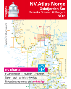
NO 2: NV.Atlas Norge - Oslofjord Sør (Svenska Grensen til Kragerø)

- FREE Delivery to UK - Spend over £75
- FREE Delivery to Europe - Spend over £150
- Worldwide Delivery Available
This atlas contains a download code for all charts in this area to be used with the nv chart app. The app is compatible with Apple: iOS/MacOSX, Android & Windows: 7/8/10.
Product Details
Part Number: YOT0006NO2
Scale: 1:1(Various)
ISBN: 9783945902158
Publisher: NV Charts
Edition: 2023
Printed and corrected to: No
Format: Combipack - Paper / Download and app
MPN: 9783945902158
- New edition spring 2018
- Passage Charts
- Coastal Charts
- Details
- Harbour Plans paper & digital
- notes in english and norwegian
The NV. Atlas Norge NO 2 - Oslofjorden Sør - Svenska Grensen til Kragerø (Oslofjord southern part - Swedish border to Kragerø) includes passage and overview charts (scales from 1:1.400.000 to 1:120.000), coastal charts (scale 1:40.000) and 13 harbour details scales 1:5.00 to 1:25.000). The combipack includes overview charts covering the entire Norwegian coast (scale 1:1.400.000) giving general information on currents. The combipack appears in nv charts new handy Atlas format (A3) and includes paper and digital charts, as well as a navigation software and nv charts free navigation app for mobile devices and tablet PC's. nv charts for the Norwegian coast are based on official Norwegian HO data. They include numerous harbour details and approaches, passages and anchorages of the given area, including sketches and plans from the “Norske Los” and special charts for the Blindleia and Jomfruland. The clear structure makes finding harbour details or anchorages a matter of seconds. In this way the mariner gets quick access to all important navigational information. All information is also shown in the nv charts App.The cartography captivates through well-chosen sheet cuts and ideal scales: e.g.coastal charts scale 1: 40.000.
Maßstäbe / Scales
Übersegler
C1 Skagerrak to Oslofjord 1: 375.000
C2 Oslofjord South 1: 120.000
C3 Larvik to Risør 1: 120.000
C21 Norway · Oslo to Mo-i-Rana 1: 1.750.000
C22 Norway · Mo-i-Rana to Kirkenes 1: 1.750.000
C23 North Atlantic Ocean 1: 14.500.000
Revierkarten
C4 Fredrikstad Approach 1: 40.000
C5 Singlefjord 1: 40.000
C6 Søndre Sandøy to Torbjørnskjær 1: 40.000
C7 Hollenderbåen to Torbjørnskjær · Færder 1: 40.000
C8 Færder to Veierland 1: 40.000
C9 Veierland to Svenner · Sandefjordsfjord 1: 40.000
C10 Svenner to Tvistein · Larviksfjord 1: 40.000
C11 Tvistein to Langesundsbukt 1: 40.000
C12 Langangs-, Eidanger- and Frierfjord 1: 40.000
S13 Langesundsbukta to Jomfruland 1: 40.000
S14 Kragerø Approach 1: 40.000
Details
C15 Fredrikstad 1: 10.000
C16A/B Stavern · Hystad 1: 10.000
C17 Langesund og Helgeroa 1: 20.000
C18 Brevik Approach 1: 20.000
C19 Jomfruland 1: 20.000
C20A Porsgrunn to Skien 1: 22.000
C20B Utgårdskilen 1: 10.000
C20C Langesund 1: 10.000
C20D Verdens Ende 1: 5.000
C20E Portør 1: 10.000
C20F Krakerø 1: 10.000