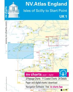
UK 1: NV.Atlas England - Isles of Scilly to Start Point

- FREE Delivery to UK - Spend over £75
- FREE Delivery to Europe - Spend over £150
- Worldwide Delivery Available
This atlas contains a download code for all charts in this area to be used with the nv chart app. The app is compatible with Apple: iOS/MacOSX, Android & Windows: 7/8/10.
Product Details
Part Number: YOT0006UK1
Scale: 1:1(Various)
ISBN: 9783945902165
Publisher: NV Charts
Edition: 2023
Printed and corrected to: No
Format: Combipack - Paper / Download and app
MPN: 9783945902165
nv charts for Great Britain are based on official data of the British Hydrographic Office (UKHO). They include numerous harbourplans and details for approaches, passages and anchorages of the given area, extra details for rivers and channels, as well as bridge clearances, opening times and notes and warnings for the given waters. Buoys and marks are shown according to the international IHO regulation. The clear structure makes finding harbour details or anchorages a matter of seconds. In this way the mariner gets quick access to all important navigational information. All information is also shown in the nv charts App.
• 1 Passage Chart
• 23 Coastal Charts & Details
• Tide Tables & Tidal Streams
• nv charts App Code
Update
NV. Atlas for the United Kingdom is published every two years.

![NP255 - ADMIRALTY Tidal Stream Atlas: Falmouth to Padstow [including Isles of Scilly]](https://www.bookharbour.com/media/catalog/product/cache/f073062f50e48eb0f0998593e568d857/n/p/np255_1.jpg)


![Channel Havens: Secret Inlets & Secluded Anchorages of the Channel [BACKORDER]](https://www.bookharbour.com/media/catalog/product/cache/f073062f50e48eb0f0998593e568d857/p/i/pil0580.jpg)