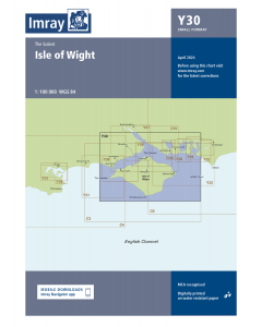
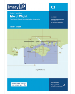
C3 Isle of Wight (Imray Chart)

- FREE Delivery to UK - Spend over £75
- FREE Delivery to Europe - Spend over £150
- Worldwide Delivery Available
England - South Coast Imray Chart
Product Details
Part Number: YOT0100
Scale: 1:60000
ISBN: 9781786795670
Publisher: Imray Laurie Norie And Wilson Ltd
Edition: 2024
Printed and corrected to: March 2024
Format: Sheet size 787 x 1118mm. Waterproof. Folded in plastic wallet.
Language: English
MPN: ICC3-7
A passage planning chart ideal for sailing near or around the Isle of Wight. This chart has been reschemed to better complement the other folded charts in our Solent chart range (C15, Y33). Coverage has been adjusted to show the full circumnavigation of the Isle of Wight including the south coast passage. Inset plans of the Needles Channel and Bembridge Harbour and approaches are included.
The latest official UKHO data is combined with additional information sourced from Imray's network to make it ideal for small craft.
New: Vessel Traffic Services (VTS) reporting points
Imray charts for the Solent and approaches now include all VTS reporting points found in these waters. VTS reporting is mandatory for vessels of more than 20m in length that are bound to and from the Solent.
Plans included: Needles Channel (1:35 000)
Bembridge Harbour & Approaches (1:10 000)
The chart is designed to be used alongside C15 The Solent for combined coastal navigation, approach, and harbour detail in and around the Solent and Isle of Wight.


![Eyeball Chart Plotter [Laminated] - The Solent](https://www.bookharbour.com/media/catalog/product/cache/f073062f50e48eb0f0998593e568d857/y/o/yot7065.jpg)


![NP255 - ADMIRALTY Tidal Stream Atlas: Falmouth to Padstow [including Isles of Scilly]](https://www.bookharbour.com/media/catalog/product/cache/f073062f50e48eb0f0998593e568d857/n/p/np255_1.jpg)


![Channel Havens: Secret Inlets & Secluded Anchorages of the Channel [BACKORDER]](https://www.bookharbour.com/media/catalog/product/cache/f073062f50e48eb0f0998593e568d857/p/i/pil0580.jpg)