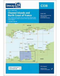
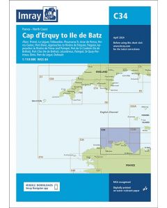
C34 Cap D'Erquy to Ile De Batz (Imray Chart)

- FREE Delivery to UK - Spend over £75
- FREE Delivery to Europe - Spend over £150
- Worldwide Delivery Available
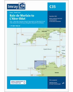
France - North Coast Imray Chart
Product Details
Part Number: YOT0410
Scale: 1:110000
ISBN: 9781786795908
Publisher: Imray Laurie Norie And Wilson Ltd
Edition: 2024
Printed and corrected to: March 2024
Format: Sheet size 787 x 1118mm. Waterproof. Folded in plastic wallet.
Language: English
MPN: ICC34-3
Plans included:
- Primel (1:15 000)
- Le Léguer (1:42 500)
- Trébeurden (1:25 000)
- Ploumanac’h (1:10 000)
- Anse de Perros (1:30 000)
- Perros-Guirec (1:15 000)
- Port-Blanc (1:25 000)
- Approaches to Rivière de Tréguier (1:45 000)
- Tréguier (1:15 000)
- Approaches to Rivière de Trieux and Paimpol (1:50 000)
- Port de la Corderie (Ile de Bréhat) (1:15 000)
- Port Clos (Ile de Bréhat) (1:10 000)
- Lézardrieux (1:15 000)
- Paimpol (1:15 000)
- St-Quay-Portrieux (1:25 000)
- Binic (1:12 500)
- Port du Légué (1:20 000)
- Dahouët (1:10 000)


![NP255 - ADMIRALTY Tidal Stream Atlas: Falmouth to Padstow [including Isles of Scilly]](https://www.bookharbour.com/media/catalog/product/cache/f073062f50e48eb0f0998593e568d857/n/p/np255_1.jpg)


![Channel Havens: Secret Inlets & Secluded Anchorages of the Channel [BACKORDER]](https://www.bookharbour.com/media/catalog/product/cache/f073062f50e48eb0f0998593e568d857/p/i/pil0580.jpg)