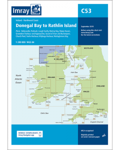
C53 Donegal Bay to Rathlin Island (Imray Chart)

- FREE Delivery to UK - Spend over £75
- FREE Delivery to Europe - Spend over £150
- Worldwide Delivery Available
Ireland North Coast Imray Chart
Product Details
Part Number: YOT0636A
Scale: 1:200000
ISBN: 9781786790583
Publisher: Imray Laurie Norie And Wilson Ltd
Edition: 2018
Printed and corrected to: March 2023
Format: Sheet size 787 x 1118mm. Waterproof. Folded in plastic wallet.
Language: English
MPN: ICC53-2
Plans included:
Ballycastle (1:5000)
Portrush (1:15 000)
Lough Swilly (1:45 000)
Mulroy Bay (1:30 000)
Sheep Haven (1:30 000)
Gweedore Harbour and Approaches (1:40 000)
Sound of Aran and Burtonport (1:30 000)
Church Pool (1:20 000)
Teelin Harbour (1:10 000)
Killybegs Harbour (1:12 500)
Mullaghmore Bay (1:50 000)
On this 2018 edition the chart specification has been improved to show coloured light flashes. Depths have been updated from the latest surveys where available. New plans of Ballycastle and Church Pool are now included. There has been general updating throughout.

![NP255 - ADMIRALTY Tidal Stream Atlas: Falmouth to Padstow [including Isles of Scilly]](https://www.bookharbour.com/media/catalog/product/cache/f073062f50e48eb0f0998593e568d857/n/p/np255_1.jpg)