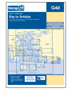
G40 Kas to Antalya (Imray Chart)

- FREE Delivery to UK - Spend over £75
- FREE Delivery to Europe - Spend over £150
- Worldwide Delivery Available
Turkey, South Coast Imray Chart - 1:200,000 Scale
Product Details
Part Number: YOT3040
Scale: 1:200000
ISBN: 9781846236297
Publisher: Imray Laurie Norie And Wilson Ltd
Edition: 2014
Printed and corrected to: January 2024
Format: Sheet size 640 x 900mm. Waterproof. Folded in plastic wallet.
Language: English
MPN: ICG40-1
Publisher: Imray Laurie Norie And Wilson Ltd
ISBN: 9781846236297
Edition: 2014
Scale: 1:200,000
Plans included:
- Kekova Roads (1:40 000)
- Kekova Adasi (1:15 000)
- Finike (1:17 500)
- Antalya Celebi Marina (1:15 000)
- Kemer Turkiz Marina (1:17 500)
For this 2014 edition the chart has been fully updated and modernised. The latest known depths are shown around Kas, Kekova Roads and Antalya Harbour. Harbour depths at agiz are also displayed, as are the recently deployed AIS transmitters across the chart.