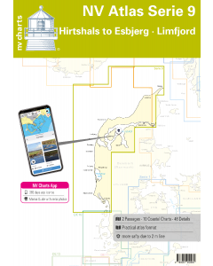
NV Atlas Serie 9: Hirtshals to Esbjerg & Limfjord

- FREE Delivery to UK - Spend over £75
- FREE Delivery to Europe - Spend over £150
- Worldwide Delivery Available
This atlas contains a download code for all charts in this area to be used with the nv chart app. The app is compatible with Apple: iOS/MacOSX, Android & Windows: 7/8/10.
Product Details
Part Number: YOT0006DE9
Scale: 1:1(Various)
ISBN: 9783945902080
Publisher: NV Charts
Edition: 2023
Printed and corrected to: edition date
Format: Combipack - Paper / Download and app
MPN: 9822
The Danish west coast and the Limfjord are among the most popular holiday regions in the Scandinavian country. The coast is known for its endless, fine sandy beaches. The Limfjord is an elongated sound that connects the North Sea with the Kattegat. The shore is lined with white cliffs, beautiful landscapes and small towns such as Aalborg, Lemvig or Skive. Numerous marinas offer berths and solid infrastructure for travelers.
With the charts of the NV Atlas Series 9 you create a safe basis for your journey through the entire area of the Danish west coast and the Limfjord. The Hirtshals to Esbjerg & Limfjord is delivered as a combination pack and contains the nautical charts in various scales as well as all harbour plans and details for approaches and passages in the waters. In addition, clearance heights for bridges, high-voltage lines and all nautical and navigational information are included. Thanks to the clear structure as a bound atlas, the water sports enthusiast can quickly find approaches, harbours and anchorages and is informed of important navigational details that also appear in the NV Charts app. The chart series impresses with its optimal scales and balanced sheet cuts.
This chart set includes
- 2 oversailers
- 10 precinct charts
- 48 details
- digital charts including
- nv charts app and navigation software
- Navigation instructions in English
Update - Update
The chart sets for the German North Sea are published annually in updated editions. Up-to-date nautical charts are the basis of safe navigation. NV Charts offers a monthly update service for its German North Sea charts from April to October. So that you are always "up-to-date".
NV Atlas chart format
NV Charts nautical charts are available in an outstandingly practical, handy atlas booklet format and thus offer many advantages over formats from other manufacturers. The nautical chart series have been designed by nautical experts and passionate water sports enthusiasts with the needs of recreational boating in mind.
The NV Atlas has a very flat staple binding in the middle, so that the course triangle can also be used there without any problems. This innovative development makes it possible to look up charts quickly and always have them in the best possible order at the same scale. The NV Atlas is delivered in a plastic cover protected against splash water. This modern nautical chart format is very popular on sailing boats as well as on motor yachts and is the preferred choice of many of our customers.
NV Charts navigation app
All NV Charts nautical charts also include an access code to the digital nautical charts in the NV Charts app and can thus be easily downloaded and used for offline navigation with the NV Charts app on iOS, Android, PC and Mac or also in the web browser.
The NV Charts app is the ideal addition on mobile devices. With the app, you can already plan a detailed route at home and thus prepare for your journey in the best possible way in conjunction with the paper chart. The app is intuitive to use and, thanks to an identical map image, you can orientate yourself on paper and digitally in a matter of seconds. The most up-to-date information is essential to navigate safely on the water with your sailboat or motorboat.
With the NV Charts app, you now have the opportunity to become part of the chart community. You can mark harbours, anchorages and navigation warnings on the digital nautical chart and also add interesting places beyond navigation, such as restaurants, with pictures and comments and share your experiences with other users. In addition, the NV Charts app offers an automatic routing function, search and all navigation functions for GPS navigation with your phone or tablet. More information at: nvcharts.com/app
More PC navigation apps: NV Verlag / NV Charts nautical charts can also be used in many other nv.digital compatible PC navigation programs such as NV Chart Navigator or Open CPN.
Containing charts and scales
Oversailers
C1 Skagen to Thyborøn 1: 375.000 C2 Thyborøn to Rømø 1: 375.000
Charts of the area
C3 Horns Rev - Esbjerg 1: 130.000 C4A Thyborøn Kanal 1: 45.000 C4B Esbjerg Approach 1: 50.000 C5 Thyborøn - Limfjord West 1: 80000 C7A Thisted Bredning 1: 80000 C7B Lovns Bredning 1: 80000 C8 Aggersund to Egholm 1: 60000 C9 Egholm to Hals 1: 60000 C13J Hals Approach 1: 45.000
Details
C7C Virksund 1: 7500 C9A/B Aalborg - Mou Bro 1: 40/4000 C10A-F Doverodde - Thisted - Sundby - Vilsund - Hjarbæk - Skive Marina 1: 2-5.000 C10G-L Esbjerg - Hirtshals - Thorsminde - Hvide Sande - Hanstholm 1: 10-15.000 C11A-N Lem Vig - Thyborøn Havn - Lemvig Marina - Lemvig Havn Agger - Struer Bugt - Struer Havn - Sillerslev Havn - Jegindø - Venø - Oddesund - Handbjerg - Gyldendal 1: 3-40.000 C12A-L Nykøbing - Amtoft - Glyngøre - Fur - Rønbjerg - Livø Havn - Løgstør - Sundsøre - Hvalpsund Fiskerihavn - Ejerslev Havn - Hvalpsund Marina 1: 3-8.000 C13A-H Gjøl - Nørresundby - Nørre Uttrup - Attrup - Haverslev - Nibe Aalborg Fjordparken - Aalborg Skudehavn - Vestre Bådehavn 1: 3-6.000 C13K/L Hals - Egense 1: 5.000
This document has been composed with the free online HTML converter. Access it here and use it every time for document editing.