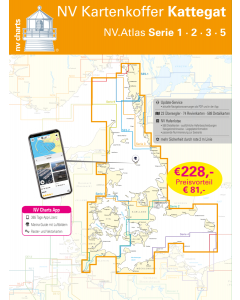
NV.Kartenkoffer Kattegat - NV.Atlas Serie 1, 2, 3, 5.1& 5.2

- FREE Delivery to UK - Spend over £75
- FREE Delivery to Europe - Spend over £150
- Worldwide Delivery Available
This atlas contains a download code for all charts in this area to be used with the nv chart app. The app is compatible with Apple: iOS/MacOSX, Android & Windows: 7/8/10.
Product Details
Part Number: YOTSET2
Scale: 1:1(Various)
ISBN: 9783910644113
Publisher: NV Charts
Edition: 2024
Printed and corrected to: edition date
Format: Combipack - Paper / Download and app
MPN: 1715
Whoever wants to save money and still be optimally equipped to travel from the Bay of Kiel to the Norwegian border is very well equipped with the Kattegat case . Instead of the series 4 (Rügen) the Kattegat case contains the two map sets 5.2 and 5.1 in order to reach the Swedish west coast as far as the Norwegian border in the direction of Oslofjord. The purchase of this case also offers a significant price advantage over the purchase of the individual charts.
The Kattegat case includes
- 18 oversailers
- 56 district charts & detailed charts
- nv charts app and navigation software 365 days licence
- new: Vector charts download
- Harbour Pilot in paper / digital in German and English
- Navigation instructions in German
- Meets legal requirement for up-to-date paper charts on board pleasure boats
Including maps and scales
Oversailers
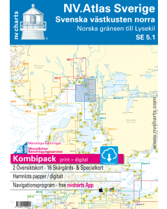
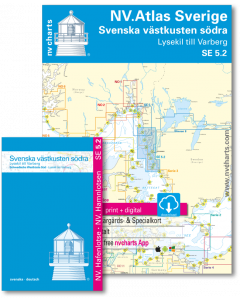
Overview map series 1 1 : 370.000 S 1 Kiel Bight 1 : 140.000 Overview map series 2 1 :520.000 S 15 Mecklenburg Bight 1 :150.000 S 16 Møn Southeast 1 :150.000 S 22 Hanö Bay 1 :260.000 S 23 Sund South 1 :140.000 S 24 Klintholm to Bornholm 1 :220.000 S 25 Bornholm 1 :140.000 General Map Series 3 1 : 520.000 Skagerrak 1 : 500.000 S 30 Kattegat Süd 1 : 180.000 S 31 Kattegat Mitte 1 : 180.000 S 32 Kattegat Nord 1 : 180.000 S1 Halden to Lysekil 1: 240.000 S2 Lysekil to Varberg 1: 240.000 Pilot Chart Anholt-Færder-Jomfruland 1: 750.000
Revierkarten
S 2 Kiel Fjord 1 : 40.000 S 3 Kiel Bight South-West 1 : 80.000 S 4 Flensburg Fjord 1 : 80.000 S 5 Little Belt South 1 : 80.000 S 6 Little Belt Centre 1 : 80.000 S 7 Small Belt North 1 : 80.000 S 8 North Funen 1 : 80.000 S 9 Great Belt North 1 : 80.000 S 10 Great Belt Centre 1 : 80.000 S 11 Great Belt South 1 : 80.000 S 12 South Funen 1 : 80.000 Schlei 1 + 2 1 : 35.000 NOK Kiel Canal 1 + 2 (5 maps) 1 : 55.000 S 13 Fehmarn 1 : 80.000 S 14 Lübecker Bucht 1 : 80.000 S 17 Smålandsfahrwasser West 1 : 80.000 S 18 Smålandsfahrwasser Ost 1 : 80.000 S 19 Grönsund 1 : 60.000 S 19A Guldborg Sund 1 : 60.000 S 20 Fakse Bucht 1 : 60.000 S 21 Sund Mitte 1 : 80.000 S 26 Sund Nord 1 : 80.000 S 27 Roskilde Fjord Nord 1 : 40.000 S 27A Roskilde Fjord Süd 1 : 40.000 S 28 Samsø Belt 1 :100.000 S 28A Isefjord 1 : 60.000 S 29 Aarhus Bay 1 :100.000 S 34A Mariager Fjord 1 : 55.000 S 34B Randers Fjord 1 : 55.000 S3 Krokstrand to Svinesund 1 : 40.000 S3A Åbyfjorden to Brofjorden 1 : 40.000 S4 Svinesund to Dynekilen 1 : 40.000 S5 Dynekilen to Koster Fjord 1: 40.000 S6 Koster Fjord to Havstenssund 1: 40.000 S7 Havstenssund to Bramskär 1: 40.000 S8 Bramskär to Hamburgsund 1: 40.000 S9 Hamburgsund to Smögen 1: 40.000 S10 Smögen to Fiskebäckskil 1: 40.000 S11 Gullmarn Fjord 1: 40.000 S3 North of Orust 1: 40.000 S4 East of Orust 1: 40.000 S5 North of Tjörn 1: 40.000 S6 East of Tjörn 1: 40.000 S7 Fiskebäckskil to Käringön 1: 40.000 S8 Käringön to Marstrand 1: 40.000 S9 Marstrand to Sälö 1: 40.000 S10 Sälö to Öckerö 1: 40.000 S11 Öckerö to Vinga 1: 40.000 S12 Vinga to Tistlarna 1: 40.000 S13 Tistlarna to Malö 1: 40.000 S14 Malö to Ringhals 1: 40.000 S15 Ringhals to Varberg 1: 40.000 S16A Nordre Älv 1: 40.000 S16C Kungsbackafjord 1: 40.000
Detail maps
S 3A Eckernförder Bucht S 4A Innere Flensburger Förde 1 : 35.000 S 5A Haderslev Fjord and approaches S 6A Alssund & Augustenborgfjord 1 : 25.000 S 7A Snævringen & Kolding Fjord 1 : 40.000 S 9A approaches Nyborg - Korshavn - Korsør S 10A Odense Fjord 1 : 40.000 S 11A Nakskov Fjord 1 : 40.000 S 12A Svendborgsund 1 : 15.000 S 13A Fehmarnsund 1 : 30.000 S 14A The Travemündung 1 : 17.000 S 16A Wismar Bucht 1 : 41.000 S 17A Ports of Rostock Gedser Anst. 1 : 20.000 S 18A Ansteuerungen 1 : 20.000 S 20A Salzhaff 1 : 41.000 S 21A Die Untertrave 1 : 15.000 S 22A Copenhagen 1 : 40.000 S 33A Ansteuerung Frederikshavn 1 : 40.000 S 33B Ansteuerung Hals 1 : 45.000 S 35A Nordansteuerung Sund 1 : 65.000 S 35B Hallands Väderö 1 : 40.000 S12 Koster Skärgården 1: 20.000 S13 Grebbestad to Fjällbacka 1: 20.000 S14 Fjällbacka to Dannemark 1: 20.000 S15 Dannemark to Sotekanal 1: 20.000 S16 Smögen to Malmön 1: 20.000 S17 Malmön to Lysekil 1: 20.000 S3A Råbergsund 1: 10.000 S16B Nordre Älv Flood barrage 1: 3.000 S17 Lysekil to Gullholmen 1: 20.000 S18 Gullholmen to Käringö Fjord 1: 20.000 S19 Käringö Fjord to Kyrkesund 1: 20.000 S20 Kyrkesund to Klädesholmen 1: 20.000 S21 Marstrand 1: 20.000 S22 Öckerö to Vinga 1: 20.000 S23 Långedrag to Vrångö 1: 20.000
Sweden NV.Atlases
-
-
-
NV.Kartenkoffer Kattegat - NV.Atlas Serie 1, 2, 3, 5.1& 5.2
Special Price £269.00 Regular Price £404.95Stock In stock
Baltic Sea NV.Atlases
-
-
-
-
-
-
-
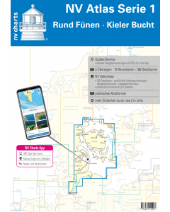
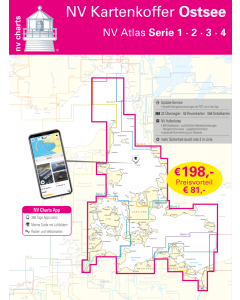
NV.Kartenkoffer Ostsee - NV.Atlas Serie 1, 2, 3 & 4
Special Price £249.00 Regular Price £339.96Stock In stock -
NV.Kartenkoffer Kattegat - NV.Atlas Serie 1, 2, 3, 5.1& 5.2
Special Price £269.00 Regular Price £404.95Stock In stock -
Baltic Sea Cruising Guides & Pilot Books


Baltic Sea Courtesy Flags


Baltic Sea Germany & Denmark NV.Atlases
-
-
-
-
NV.Kartenkoffer Ostsee - NV.Atlas Serie 1, 2, 3 & 4
Special Price £249.00 Regular Price £339.96Stock In stock -
NV.Kartenkoffer Kattegat - NV.Atlas Serie 1, 2, 3, 5.1& 5.2
Special Price £269.00 Regular Price £404.95Stock In stock -
